WingtraRAY
Wingtra · Switzerland · Updated
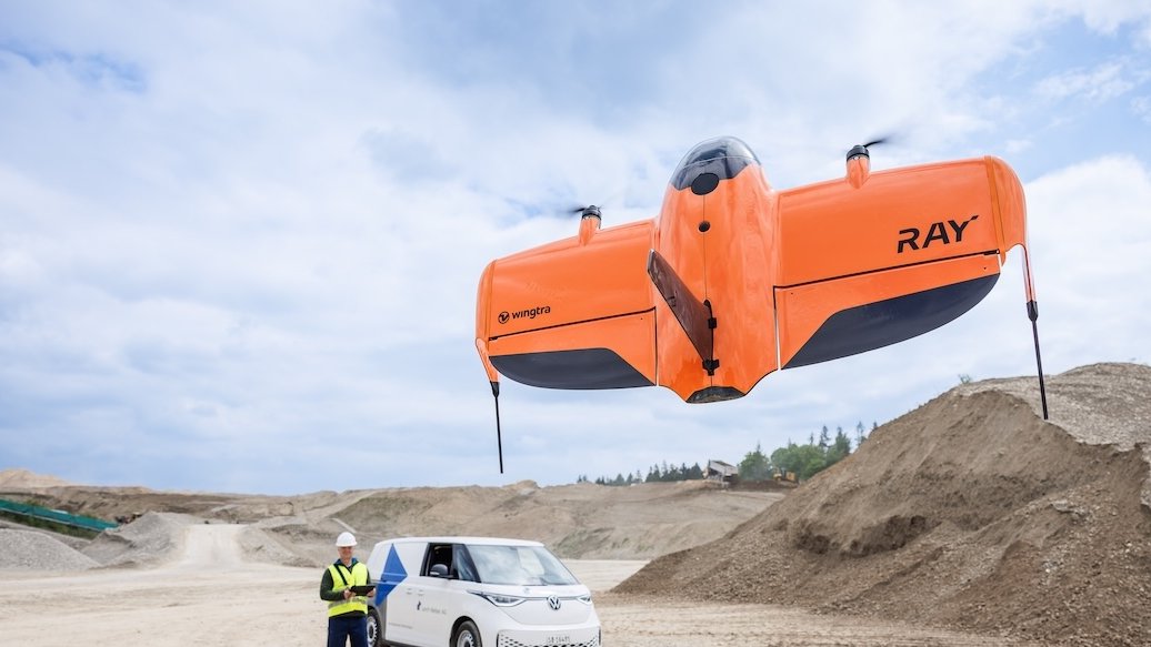
WingtraRAY is a tailsitter vertical take-off and landing (VTOL) fixed-wing drone developed by Wingtra of Switzerland for aerial surveying and mapping, launched in select countries on 10 July 2025. It replaces the WingtraOne GEN II as Wingtra's flagship survey aircraft and adds a certified parachute option for flight over people.
Overview
WingtraRAY is built for professional surveyors, construction firms, mining operations and other mapping customers who need photogrammetric or LiDAR-grade data without a runway, catapult or net-recovery system. Wingtra's product page describes it as part of an end-to-end system that pairs the aircraft with a rugged field tablet, the WingtraGROUND base station and the cloud-based WingtraCLOUD processing platform. DRONELIFE reported that the aircraft became available in select countries from 10 July 2025, with a global rollout to follow.
The aircraft is marketed as roughly 40% faster to operate than the WingtraOne GEN II it replaces, and Wingtra's technical specifications describe the whole workflow — from flight planning to CAD- and GIS-ready outputs — as built to cut field and processing time compared with both terrestrial surveying and multirotor drones.
Design and capabilities
WingtraRAY takes off and lands vertically as a tailsitter, then transitions to level fixed-wing flight for efficient cruising, so it needs no runway, catapult or parachute-free belly landing. Wingtra's official technical specifications (February 2026, version 2.7) give a wingspan of 125 cm (4.1 ft), a maximum take-off weight of 5.2 kg (11.5 lb) and a maximum payload capacity of 1,250 g (2.75 lb). Two swappable 99 Wh lithium-polymer batteries power the aircraft, and cruise speed adapts between 16 and 22 m/s (36–49 mph) depending on conditions.
Maximum flight time is 59 minutes with the RGB, oblique or multispectral payloads (MAP61, SURVEY61, INSPECT, RedEdge-P or SURVEY24) and 45 minutes with the LiDAR payload, according to the manufacturer's specifications. A primary 2.4 GHz telemetry radio link covers up to 10 km (6 mi) in direct line of sight, with an LTE fallback for beyond-visual-line-of-sight operation within mobile network coverage. The aircraft can fly up to a maximum altitude of 5,000 m (16,400 ft) AMSL with high-altitude drivetrains, or 2,000 m (6,600 ft) with standard drivetrains, and tolerates sustained winds up to 12 m/s (27 mph). Wingtra states an absolute accuracy of 3 cm (0.1 ft) RMS with post-processed kinematic (PPK) positioning, achievable without ground control points for the SURVEY61 and LiDAR payloads.
In a single one-hour flight with the MAP61 camera, Wingtra's specifications state the aircraft can cover up to 550 ha (1,360 ac) at 2.7 cm/px ground sample distance. The INSPECT payload, aimed at close-range infrastructure inspection, reaches a ground sample distance as fine as 0.25 cm/px at 60 m (200 ft) altitude. An optional certified parachute allows operation over people under the US FAA's Category 3 rules and the EU's EASA C6/STS-02 framework.
Use cases
WingtraRAY is used for large-area topographic mapping, construction and mining site surveys, agricultural field mapping, and infrastructure inspection, wherever a customer needs centimeter-level photogrammetric or LiDAR data over an area too large for an efficient multirotor survey. Wingtra positions it specifically for professional surveying teams already using CAD or GIS software, since captured data feeds directly into WingtraCLOUD for processing and export.
Variants
WingtraRAY succeeds the WingtraOne GEN II, Wingtra's previous flagship survey drone; Wingtra's own materials state WingtraRAY is roughly 40% faster in typical survey workflows. Wingtra says GEN II customers can reuse several existing sensor payloads — including the MAP61, LiDAR, RedEdge-P and RX1R II — on WingtraRAY with an upgrade mount.
Frequently asked questions
What is the flight time of WingtraRAY?
Up to 59 minutes with the RGB, oblique or multispectral payloads, or 45 minutes with the LiDAR payload, according to Wingtra's technical specifications.
How heavy is WingtraRAY?
Its maximum take-off weight is 5.2 kg (11.5 lb), with a maximum payload capacity of 1,250 g (2.75 lb).
Does WingtraRAY need a runway?
No. It is a tailsitter VTOL aircraft that takes off and lands vertically, without a runway, catapult or net.
What replaced the WingtraOne GEN II?
WingtraRAY, launched in select countries on 10 July 2025, succeeded the WingtraOne GEN II as Wingtra's flagship survey drone.
What is the accuracy of WingtraRAY surveys?
Wingtra states an absolute accuracy of 3 cm (0.1 ft) RMS using post-processed kinematic (PPK) positioning, following its recommended base-station workflow.