Delair UX11
Delair · France · also known as Delair-Tech UX11 · Updated
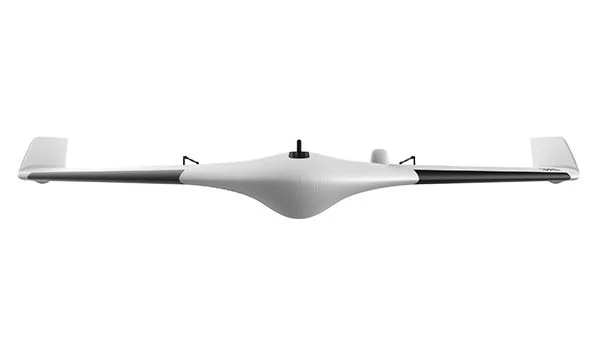
The Delair UX11 is a hand-launched, fixed-wing mapping drone built for large-area aerial surveying with centimeter-level positioning accuracy.
Overview
Delair, a French unmanned-aircraft manufacturer headquartered in Toulouse and founded in 2011, announced the UX11 in September 2017 at the INTERGEO trade fair, with commercial availability following in early 2018. Trade coverage at the time described it as Delair's third-generation fixed-wing mapping drone, built on experience gained from the company's DT18, certified in 2012 as France's first beyond-visual-line-of-sight (BVLOS) unmanned aircraft, and on photogrammetry expertise acquired through Delair's 2016 purchase of Gatewing from Trimble.
The UX11 is positioned for geospatial professionals who need to cover large sites — mines, quarries, construction projects and infrastructure corridors — with survey-grade accuracy rather than the smaller footprints typical of multirotor drones. It integrates a proprietary camera, GNSS receiver and processing electronics into a single compact, backpack-portable airframe.
Documented users include Weaver Consultants Group, a U.S. engineering firm that adopted the UX11 for volumetric surveying and digital-twin mapping of landfill and waste-disposal sites, and a phosphate mining operation spanning sites in Idaho and Wyoming that used the platform to survey areas exceeding 200 acres per project.
Design and capabilities
The UX11 has a 1.2-meter wingspan and weighs 1.6 kg, with a stated deployment time of about five minutes from case to launch. It is hand-launched at takeoff and lands via a controlled belly landing using reversed thrust and a ground-proximity sensor, requiring roughly a 5-meter-radius clear landing zone. Delair states a wind-resistance rating of up to 45 km/h.
Onboard is a proprietary CMOS camera with a global (non-rolling) shutter and 21.4-megapixel resolution, producing a ground sample distance of about 1.7 cm when flown at 400 feet (122 m). Positioning is handled by a dual-frequency, dual-constellation GNSS board paired with Post-Processed Kinematic (PPK) correction rather than real-time RTK. Delair's documentation cites raw PPK accuracy of roughly 1 cm horizontal and 1.5 cm vertical, with final mapped deliverables typically achieving better than 6 cm horizontal and 9 cm vertical accuracy.
Connectivity combines a proprietary line-of-sight radio link with 3G/4G cellular data for command, telemetry and BVLOS-ready operation. Delair's current published specifications list an operating ceiling of 6,000 m above mean sea level for flight, a cruise speed of 54 km/h, a maximum endurance of up to 80 minutes, and a maximum range of 53 km. At the recommended 400-foot mapping altitude with 60% side overlap, a single flight can cover approximately 300 acres (120 hectares). Mission planning runs on the Delair Flight Deck app, with post-flight PPK processing and quality checks handled by Delair After Flight software, which integrates with third-party tools including Trimble Business Center, Pix4D and AutoCAD.
Use cases
The UX11 is marketed for surveying and mapping projects — such as topographic mapping, volumetric measurement and 3D/2D site modeling — in mining and aggregates, construction and infrastructure, and waste-management sectors. Weaver Consultants Group uses the UX11 to build digital twins of landfill sites and to run repeated volume calculations for land-use management, reporting the ability to complete roughly 900 acres of coverage in a day across three or four 45-minute flights. A separate phosphate mining operation used the platform to survey sites exceeding 200 acres across Idaho and Wyoming for materials quantification and site planning.
Frequently asked questions
What is the Delair UX11's wingspan and weight?
The UX11 has a 1.2-meter wingspan and weighs 1.6 kg.
How long can the UX11 fly?
Delair's current specifications list a maximum endurance of up to 80 minutes; earlier product documentation cited up to 59 minutes on a full charge.
What area can one flight cover?
At a 400-foot (122 m) mapping altitude with 60% side overlap, a single UX11 flight covers approximately 300 acres (120 hectares).
What positioning accuracy does the UX11 achieve?
Using PPK correction with its dual-frequency, dual-constellation GNSS receiver, raw accuracy is approximately 1 cm horizontal and 1.5 cm vertical, with final mapped deliverables typically better than 6 cm horizontal and 9 cm vertical.
What is the UX11's range and cruise speed?
Delair lists a maximum range of 53 km and a cruise speed of 54 km/h, with an operating ceiling up to 6,000 m above mean sea level.
When was the UX11 introduced?
Delair announced the UX11 in September 2017 at the INTERGEO trade fair, with commercial availability following in early 2018.
SourcesChecked
- Professional Mapping Drone: discover the Delair UX11 UAV
- FAQ of the Delair UX11: the professional surveying and mapping drone
- Delair (company) — Wikipedia
- DELAIR to Announce the UX11, New Compact Fixed Wing Drone
- The Delair UX11 UAV: Professional Grade Fixed Wing Covers More Ground
- Weaver Consultants Group moves to Delair UX11 UAV for large scale aerial-based topographic mapping